2013 100 Miles of Nowhere Race Report: “here is That Wascly Wabbit?” Edition
by John M (aka Arizona Guy) – MON racer # 6467
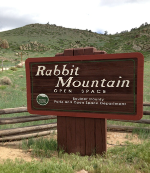
Living in the Boulder foothills, I had some interesting options to consider. I thought the local famous hills, Flagstaff and Old Stage seemed to fit the dimensions… but frankly sounded too painful. There are the ‘fruit loops’ in Lyons with some beautiful canyons and very conveniently located near Oscar Blues Brewpub, but I decided to ride back and forth on a stretch of road known as Rabbit Mountain.
This is a nice out & back option off the one of the standard road loops around here, that I estimated at about 5 miles, with a good grunt of a hill at the end. I declined to measure it on Google ahead of time, and preferred to measure it on ‘race’ day. I also remembered a trailhead there with a shelter, bathroom and the hope ( later dashed) of water.
Race day turned out to be rather cool, about 50 when I got up and I lazed around gathering food, reading the paper and feeding the dog ‘til about 8. I loaded up one of the kids old school backpacks with a jug of water, a couple juices and my excellent Honey Stinger snack pack as well as a baggie full of Gu Brew in a suspicious blue color.
I rode out through the tail end of a local triathlon with back-of-the-pack riders providing some traffic and scenery. I’m no powerhouse, and was taking it easy riding up the road AND carrying a 15 pound backpack, but I nevertheless was overtaking some people struggling up the hills on their tri bikes, aero helmets and all. Soon enough, the racers turned off and I had the road mostly to myself heading to the Rabbit Mountain turnoff – which turned out to be 12.5 miles from my front door. That made for easy math – I owed 75 miles of laps on Rabbit Mountain to qualify as a MONarch.
Rabbit Mountain road (actually 53rd St) borders a Cemex quarry and trends up gently, through prairie (you can’t see the actual quarry pit) makes a bend or two until it reaches the Rabbit Mountain Open Space trailhead, then makes a left turn up past a few houses perched on Rabbit Mountain itself and a fairly steep climb.

The Trailhead Parking lot, the thunderbox, and the welcome cloud cover
As it turned out, the Trailhead was 3 miles from the road, and almost exactly 1 more mile to the crest of the hill, where the pavement ends and I made my turnaround. Total distance was a nice even 4 miles, making an 8 mile loop. That seemed great, I had estimated 5 miles – so now I only had to do 10 laps instead of 15!
The elevation at the low point near the road was exactly 5280, and the peak of the climb was 5670, so about 400 feet of climbing on each lap, with half over the first 3 miles, and the last mile climbing 200 feet with the steepest pitch at about 10-11%.
Of course, this also meant I had a 400-foot descent every lap.
I dropped my backpack at the trailhead rest area and got to work. I clocked my first lap at just over 30 minutes and for the most part held that pace throughout, my fastest lap was 28:30, my slowest 31:something.
One of the nice features of the road was that it was a dead end with almost no traffic, except for hikers and bikers driving to the trailhead. I was hoping for a steady stream of roadies to chat with on my laps, but outside of my second lap, I rode on my own the whole way, although a dozen or two riders passed me going opposite ways on the road.
My company for the ride was a steady whack-a-mole progression of barking prairie dogs who would wag their tails and bark to alert their neighbors of my approach, scurry to the mouth of their burrow and watch to see if I looked hungry. As the miles and hours passed, I got hungrier and began to consider how I might catch and roast a few, so their concern was not entirely misplaced.
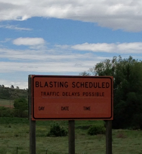
Since this was a quarry, there was also the possibility of entertainment in the form of large explosions. I rode for hours in the hopes of hearing ‘Fire in the hole!!’ but finished the day disappointed.
I also had a field full of birds to watch: hawks, mockingbirds, some optic-yellow number that looked too bright to be real, and for one magnificent lap a pair of golden eagles. I was watching one of them flying over the field from a distance and realized it had to be bigger than a hawk, and about the time I started to suspect an eagle sighting, I realized I was riding past his (her?) mate who was perched on a fence post not more than 10 feet from me. Magnificent.
What I never saw the entire day, was a single rabbit. Perhaps the prairie dogs chased them off….
I did have a low point about mile 40, when you realize that a few hours have gone by and there were many more to go. I was feeling some numb hands and wondering why I should stay out for most of the rest of the day. This seemed like a good time for a break, so I went and sat in the shelter, took a bathroom break, ate some food and did a bit of stretching. The sun came out, and I pushed off and headed up the hill.
Once I got going again, the day went by pretty fast… I crossed 50 miles, then before long I was at 60-something and had to calculate my finishing laps. I figured out that 9 laps would bring me to the end of the road with 83 miles, and 12.5 miles home. Hoping that the 12 miles I rode to the mountain would turn into something more like 15, I gathered my bag and headed for home.
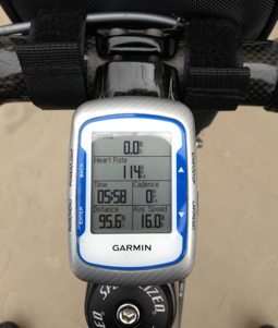
Unsurprisingly, I pulled into my driveway with 96 miles showing on Mr. Garmin. I thought about dumping my bag and riding through the neighborhood across the street which had a few blocks I could make a loop around to round out the mileage – then I remembered that I was out of beer!
This gave me a motivating mission, remembering the friendly liquor store about 2 miles away. I emptied out the backpack and headed off to stock up on Oscar Blues Dales Pale Ale.
Ride Stats
Since there are lots of data junkies like me out there, I wanted to include the data from the ride. You’ll notice I ended up just shy of 98 miles – because when I left the store giddy with my fresh beer, I neglected to restart the GPS. Then when I arrived home, I ran into a neighbor eager to share my beer – so the planned car trip with the GPS in my lap to round things out never happened.
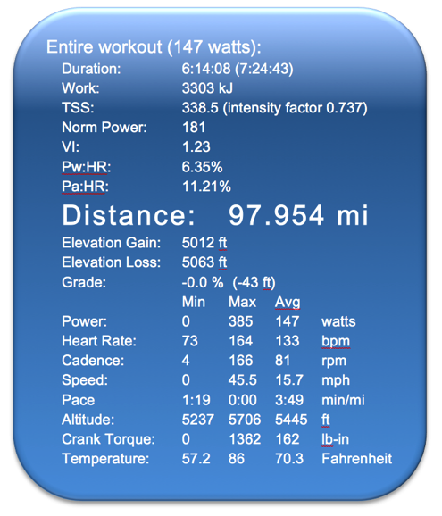
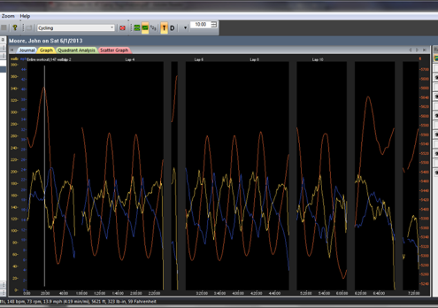
TrainingPeaks Graph
Wrapping it all up
Although I’ve done many tougher events (double centuries, Ironman Tris, 100 Mile MTB races..) I think I have generated more amazement with friends and family for the MON than almost any other. They almost always ask me to repeat the concept and stand slackjawed in amazement that I (and hundreds of other internet race-mates ) would willingly go through the mental struggle of a repetitive stretch of road like this.
It was a bit of a mental breakthrough pushing past the desire to quit, which was quite strong. On most races and rides, there are very few bailout points (Marine Corps Marathon runs you past the parking lot at about 3 miles – always a temptation..) but passing the way home every 30 minutes provides a unique temptation and tug on your determination. I’m proud I could (mostly) stick with it all the way through.

Comment by Nancy_in_MN | 06.13.2013 | 8:34 am
“Suspicious blue color” I love it! Makes me think of the time my kid ate blue ice cream…. oh never mind.
“MoNarch” must be what you are if you’ve completed a 100MoN in a roguish manner. The beer run at the end proves that you are, indeed, a MoNarch!
Great report! Loved the critter notes. I think this is what your prairie dogs were up to: http://www.youtube.com/watch?v=SNfQda8ceGs
Comment by rich | 06.13.2013 | 9:08 am
great report….would love to see a couple of eagles on a ride…very cool!
Thanks for sharing the adventure
Comment by Stef | 06.13.2013 | 9:18 am
I should have spent my last 4 miles on a beer run. Brilliant!
Comment by davidh-marin,ca | 06.13.2013 | 9:22 am
Eagles are definitely a good sign on a ride. Turkey vultures are not. Glad to see the stats kept you ahead of the buzzards.
Now should you ever have success capturing one of those woadside wascals, think;

http://www.chow.com/recipes/28393-argentine-chimichurri-sauce
Comment by John G | 06.13.2013 | 10:04 am
Great job! I love the term MONarch – stealing this.
Comment by ClydeinKS | 06.13.2013 | 11:04 am
ArizonaGuy – awesome ride and what a way to finish it!Thanks for sharing! What program did you pull the stats from, was that also Training Peaks?
Comment by Corrine | 06.13.2013 | 11:11 am
Great report! I also love the term MONarch! Sounds like a great day.
Comment by Bill H-D | 06.13.2013 | 12:56 pm
Well ridden, and well written!
My favorite turn of phrase: “…so their concern was not entirely misplaced.”
:)
Comment by cyclingjimbo | 06.13.2013 | 1:26 pm
Nice report. Flagstaff, Old Stage and Rabbit Mountain take me back to our years in the area. Nostalgia rolls over me in waves. Sniff.
Watching the prairie dog version of the wave as you ride by is entertaining, but I don’t think I have ever been hungry enough that the thought of eating one of them was appealing. You must have been really hungry.
Great place to live and ride. Thanks for the report. You are a MoNarch – nice catch word for all the MoN champions.
Comment by Fred | 06.13.2013 | 8:28 pm
“There are the ‘fruit loops’ in Lyons with some beautiful canyons…”
Thanksalot. Now I need to get out and scout some routes containing fruit trees. Every group ride needs a route called the ‘fruit loops.’ That is funny!
Nicely done. My 100MoN had some similarities. 400 feet (X10 laps) of climbing was not among them. My report is still a work in progress.
Comment by Tom in Albany | 06.14.2013 | 6:26 am
Great ride and report, zonaguy!
I think you should eat you some prarie dogs…
Hail ZonaGuy – MONarch of Boulder and the Froot Loops!
Comment by John (Arizona Guy) | 06.18.2013 | 1:57 pm
Thanks for all the comments folks, I’ve been on the road for a few days and just getting a chance to reply.
ClydeinKS: Yes, TrainingPeaks is the software, the table is copied into Word for a little nicer formatting, the chart is a simple screen-grab
The Fruit Loops actually run along Apple Valley Road in Lyons, so the road name provides the inspiration – but there are lots of apples and peaches along the way. I’ve never poached one – but maybe this year ;-)